Convergence Index
- Author: O.Conrad (c) 2001
- Menu: Terrain Analysis | Morphometry
Description
This tool calculates an index of convergence (or divergence) with respect to overland flow direction. Its meaning is similar to that of plan or horizontal curvature, but produces much smoother results. The calculation uses the aspects of surrounding cells, i.e. it looks to which degree surrounding cells point to the center cell. Index values are percentages, with negative values corresponding to convergent, positive to divergent flow conditions. Plus 100 would be the peak of a summit, 0 an even slope, and minus 100 a pit.
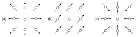
Fig. 1: Examples for index values with arrows indicating the aspect direction (a=+100%, b=0%, c=-100%).
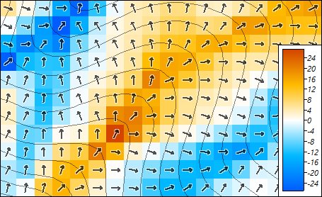
Fig. 2: Real landscape example with contour lines and arrows indicating aspect direction.
References
- Conrad, O. (1998): Ableitung hydrologisch relevanter Reliefparameter aus einem Digitalen Geländemodell (am Beispiel des Einzugsgebietes Linnengrund / Kaufunger Wald). Diploma Thesis, Dept. of Geography, University of Göttingen. online
- Kiss, R. (2004): Determination of drainage network in digital elevation models, utilities and limitations. Journal of Hungarian Geomathematics, 2, 16–29. online
- Köthe, R. & Lehmeier, F. (1996): SARA - System zur Automatischen Relief-Analyse. User Manual, 2. Edition, Dept. of Geography, University of Göttingen [unpublished].
Parameters
| | Name | Type | Identifier | Description | Constraints |
|---|
| Input | Elevation | grid, input | ELEVATION | - | - |
| Output | Convergence Index | grid, output | RESULT | - | - |
| Options | Grid System | grid system | PARAMETERS_GRID_SYSTEM | - | - |
| Directions | choice | METHOD | Use either aspect only or the full gradient (including the sloping). | Available Choices:
[0] Aspect
[1] Gradient
Default: 0 |
| Neighbourhood | choice | NEIGHBOURS | Neighbourhood used for aspect/slope calculation. Chosing '3x3' will give smoother results than '2x2'. | Available Choices:
[0] 2 x 2
[1] 3 x 3
Default: 0 |
Command Line
Usage: saga_cmd ta_morphometry 1 [-ELEVATION ] [-RESULT ] [-METHOD ] [-NEIGHBOURS ]
  -ELEVATION:    Elevation
	grid, input
  -RESULT:       Convergence Index
	grid, output
  -METHOD:       Directions
	choice
	Available Choices:
	[0] Aspect
	[1] Gradient
	Default: 0
  -NEIGHBOURS:   Neighbourhood
	choice
	Available Choices:
	[0] 2 x 2
	[1] 3 x 3
	Default: 0
Description Editor(s): O.Conrad (2026)